
Atlantic Encroachments: 3D Visualizations of Climate Change and Sea Level Rise in the Arctic
Description
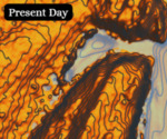
Collin Doyle took the research from the Roy Fitzsimmons’s journal documenting the MacGregor Arctic Expedition and through Mathmatica, produced three-dimensional maps that represent the same part of the Arctic that was traversed during the expedition. In doing so, Doyle illustrated the importance of climate consciousness through the creation of interactive visualizations of sea level rise. Doyle also presented a poster that features direct quotes from the journal.
Archival Collection Used: MSS 0153 Fitzsimmons Diary
Publication Date
2024
Disciplines
Environmental Sciences | United States History
Recommended Citation
Doyle, Collin, "Atlantic Encroachments: 3D Visualizations of Climate Change and Sea Level Rise in the Arctic" (2024). Cohort 2023-2024. 3.
https://scholarship.shu.edu/cohort23-24/3